Day 8: January 8th
I finally had a peaceful night's sleep and after waking up and getting ready for the day, I headed down to the hotel restaurant for breakfast and had a beautiful view! After breakfast, we all met in the lobby to start our Cuenca city tour but before we left, we dropped off our laundry to a laundromat where it cost $0.65/lb! Our first stop was at the top of a hill where we could see the whole city and the shape of the valley. The Canyari people were the first people to live here and when the Incas arrived, they believed Cuenca was a valley created by the gods because it is in the shape of a puma. Once the conquistadors arrived, they realized that there were only women and children because the Incas had killed all the men to show their dominance. In the early 1900s, there was a lot of French influence for the architecture and the city became very Catholic afterwards. The city has three "levels": downtown, old city, and new city which the locals have renamed Gringoville because all the expats live in this area of the city. Diego pointed out that there are very little people who struggle with money as everyone lives well and the economy is doing well in the city. He also said that the richest family in Ecuador lives in Cuenca as well as himself and his wife and children. For the most part, the houses are made of terra cotta and buildings are only 5 stories high but very wide. Crime rates are low because everyone here has higher education, implements clean energy, and is environmentally conscious which in turn helps with the mental health of everyone living there. In Cuenca there are big campaigns for recycling and clean energy and all new buildings are required to have motion sensor lights to reduce the amount of energy used. Another way Cuenca is helping the environment is by building an electric train that will run along the two central streets. By doing so, the buses that run there and cause smog will only run in the new city section of Cuenca. The city also encourages riding your bike since they made roads specifically for bike riders and as Diego pointed out, you need to eat a lot of carbs because "you breathe, you lose weight" since we are at such a high altitude. On the way to the next stop, we made a quick detour to a small restaurant to try cuy (AKA guinea pig). I reluctantly tried it but didn't like it so I stuck to eating the potatoes and pork that we also got. Generally cuy is served one per person along with potatoes and large corn but we all ate family style since there were so many of us.
Our next stop was the Panama Hat Factory where we got to take a tour and see the hat making process in real life! The process of Panama hat making started in 1835 and before it was only at the coast. Diego's hat is passed down from his grandfather and the model is influenced from Greece. Typically a Panama hat is built to last and be passed down through generations - there are some that are over 100 years old. Super fine fibers can be made by splitting the straw between the weaver's finger and nail. These hats are more expensive because they are more delicate to work and take longer to make. Ecuador's first export was Panama hats and today, the factory is able to produce 300 hats per day! Although the hats are fairly pricey, they make up for the price in the craftsmanship and attention to detail. Weavers make the hats from large bags of straw and before they can continue with the process, someone from the factory inspects them ensuring that the weaving is done properly. Once they are cleared, they are then bleached in a process of soaking for three weeks in a salt water bath (the water has more oxygen than normal and is heated to 60°C), laying out in full sun for a week, and then finally laying in complete shade for another week. The bleached hats can also have color added to them - these of course will be more expensive in the end. The hats are then taken to the press where they are placed in a mold and pressed at high pressure to create the designated shape. After we finished the tour, we were able to try on hats and some of us bought a hat! Our final stop was the Inca remains which is found at the puma's hand of the shape of the valley. Diego told us that the Inca's believed in the three lands and each had a god to represent it: heaven (condor), land (puma), and underworld (snake). Since we got here pretty late in the day, we weren't able to walk to the top of the remains but we were able to walk to the base and look around on the way out. Since this was the last stop, we headed back to the hotel and instead of going to dinner, I took a long nap before we had to be ready for our meeting with Tait's friend from graduate school.
Instead of a reflection meeting or a presentation, we were able to sit down with Paul Amos tonight. Tait and Paul both went to University of Florida for graduate school and stayed in touch through the years. Paul moved to Cuenca two years ago as part of his midcareer break. He originally wanted to travel and researched places that wouldn't break the bank and were safe for foreigners. He came across Ecuador in a magazine that ranked the country as #1 for retirement abroad and decided to go with it. The expat population is 5-7,000 in Cuenca alone and the expat community looks out for each other as well as plans nights or trips where they can all get together. In Ecuador there isn't need for currency exchange since they use the American bills and in Cuenca, Paul said that he feels very safe and that everything is dirt cheap. He pays $600 a month for his apartment, the bus from one end of the city to the other is $0.25, health insurance is $70/month, and fresh fruits and vegetables are super cheap. Cuenca is never too hot or too cold, has the freshest water in all of South America, not too many bugs, lots of outdoor activities, and the coast is about a 4-6 hour drive but is good for weekend trips. Paul also talked about the current political climate in Ecuador and said that the new president is really bringing the nation together and that there is a new referendum being put to vote that will not allow presidents to run indefinitely. In Ecuador, voting is mandatory and if voters do not show up, they can be fined $300-400! Voting for the country takes place on a Sunday and all bars and liquor stores are closed from Friday morning to Monday morning to ensure that the voters are thinking with a clear(ish) head. Some general observations that Paul has noticed is that the turnover rate of new expats is pretty high. Most come to Ecuador but move after 2 years because of culture shock as the country is a real eye opener to other 3rd world countries. Paul came to Ecuador knowing Spanish and can order things but is still working on his conversational Spanish however, other expats and locals are helping him to learn. The younger expats that move to Ecuador, put their children through the Ecuadorian school system - they're able to learn Spanish and help their classmates learn English. For Paul to be able to live in Cuenca, he needs a resident visa which allows him to be able to go back and forth between other countries and still be able to call the U.S. and Cuenca home. There is a 2 year probation period where he could only leave the country for 12 weeks out of the year but after that time he could leave for up to 6 months as long as all the time isn't spent in the U.S. Before we broke, I asked Paul how long it took him to get used to the altitude and he said that it took him about a month and loves going home to the U.S. for runs because he gets "oxygen smoothies" since the elevation is drastically lower. With no more questions, we said our goodbyes to Paul and thanked him for sharing his experiences. Everyone then headed back to their rooms (since we used our room for the meeting I didn't have to go anywhere) and I said goodnight to my roommates and headed to bed.

Cuy roasting along with other delicious foods |

Diego showing us a pressed hat versus one that hasn't gone in yet |

Some street art |
Day 9: January 9th
Woke up and my stomach was feeling a bit off (most likely because I was on three types of medication and the altitude medicine made me feel weird) so I skipped breakfast and ate a protein bar instead while packing all my stuff. I met up with everyone else in the lobby around 8:20 and we loaded the bus and headed north. Along the way, Diego gave us some facts: Cuenca used to have a train station built in the 1800s that connected the Andes with the coast but is no longer in use. After getting out of the city, we hopped on the PanAmerican highway north to the Inca remains. Once we got to the remains, Diego started the tour by telling us that there are three commandments that the Incas followed: do not be lazy, do not lie, and do not steal. The Inca calendar revolves around the 2 solstices (summer and winter) and the 2 equinoxes (spring and fall). After the December solstice, the Inca farmers would aerate the soil in order to prepare it for the next growing season. The Inca remains at Ingapirga were found by the government and the village surrounding them was built up to generate a profit. These remains are very important because the temple is a perfect ellipse and allowed the Incas to give full reverence to the sun since there were special spaces left open for the sun to hit perfectly during each solstice. When the Incas would build their temple and surrounding village, they needed to make sure that the shape of the land was in the shape of a puma as well as an Inca face - Ingapirga has both. The temple is the puma's brain and the large rock that was there before the Incas arrived is at the center of the puma. While we were up on the temple ruins, Diego talked about the Chakana cross and how the Incas would create a spiral and add a swirl for every year of life. There was also a point on the cross that was chosen for the person by the stars and allowed them to worship the stars more. After we finished exploring, we headed to lunch which for me was potato soup, stewed beef with rice, corn, and carrots. We then headed toward our lodge for the night but stopped a the first Catholic church in Ecuador. Iglesia de Balbenera was built in 1534 in Riobamba and is still used for regular worship as well as a destination for the more religious traveler. From there we headed to our lodge, checked in, ate dinner, and then had two presentations.
John and Hunter went first and their presentation was on Ecuador's Top 5 Chief Exports. The top five exports are oil, cacao, cut flowers, shrimp, and bananas. Surprisingly, Ecuador exports 32.4% of its goods to America and it is (not surprisingly) mostly shipped by boat with some being shipped by cargo plane. In terms of revenue, the exports listed from greatest to least is: oil which brings in $5,054 billion a year; shrimp which brings in $2,587 billion per year; bananas which brings in $2,742 billion per year; cut flowers which brings in $802 million per year; and cacao beans bringing in $622 million per year. Shrimp, however, is the largest non-oil export and shrimp export began in the 19th century and large areas of mangrove forests were clear cut in order to allow for large acres of shrimp farms to be put in place. As for Ecuadorian cacao, production grows anywhere from 2-20% each year. Ecuador is the 4th largest producer of cacao with 80% of production coming from Manabi, Los Rios, and Guayas and 7% coming from the Amazon provinces since that is the more sustainable path. Although there is 565,000 hectares to harvest, a lot of cacao farms are facing issues with black pod disease and creating a homogeneous forest. Oil is Ecuador's chief export and is the 5th largest producer in South America as well as having the 3rd largest reserves in Latin America. However, there are a number of environmental and health impacts associated with oil extraction such as deforestation, contamination of waterways, cancer, and reproductive health problems. Ecuador is the largest exporter of bananas in the world and although most of their yield stays within the nation, international export happens through Dole, Chiquita, and Del Monte. Climate change is the biggest threat to the banana yield but with adequate sunlight, deep soils, and good drainage, bananas can be plentiful. Cut flowers are the second largest agriculture export even though they are one of the lower major exports. Cut flowers only began to be exported in 1980 and the export flourished during the banana plague. Since there is a heavy use of pesticides there are health concerns associated with importing cut flowers from Ecuador.
Kevin and Aiden were next to present on Deforestation and Ecological Integrity. Deforestation is one of the largest contributors to global warming. Human related deforestation includes making way for agriculture (crop and cattle), logging (legal and illegal), oil drilling, colonization, and other extraction efforts. Non-human deforestation includes forest fires and overgrazing. Ecuador has one of the highest rates of deforestation in the world and the damage of that includes habitat loss, added carbon dioxide to the atmosphere, and dry soils which lead to greater rates of erosion. Ecuador's forests cover 35% of the total land area in the country with 80% of that being found in the Oriente region of Ecuador. The Oriente (AKA Amazon) is only 2% of the entire Amazon and half of Ecuador's total land cover. The Sierra region is the the Andes and is the middle of Ecuador from North to South. In the Sierra region, Qutio, Ecuador's capital, is located as well as the cloud forests like Mindo. The Costa region (AKA the Coast) runs from the western Andes to the Pacific. This area has logging and agriculture that is responsible for 99% of the historically forested land. Ecuador is the 8th most diverse country in the world and in order to keep it that way, deforestation practices need to be greatly limited. Before Correa left office, he approved an initiative to begin drilling in Yasuni. Drilling in Yasuni will lead to widepread pollution and a loss of biodiversity and many environmental organizations within the national are doing all they can to prevent this from happening. After the boys were finished their presentation, I headed back to my room (which was in the basement of the main part of the lodge) and went to bed knowing we had an early morning ahead.

The temple of the sun at Ingapirga |

First Catholic church in Ecuador |

Beautiful sunset at our lodge |
Day 10: January 10th
7 a.m. wake up call! I went down to the hotel restaurant for breakfast and then gathered my things to load the bus. We then headed to Chimborazo and stopped before reaching the park to take pictures. Diego took us a short cut route that allowed us to see some of the cattle farms as well as a large lake that was created by the locals to be used for water. We then picked up our local guide that would help us to climb from the one station to another. Chimborazo is part of a National Reserve that was created to protect the vicuña - the miniature cinnamon-hued cousins of the llama. Their fleece is so fine that the Incas considered it to be cloth of gold and only royalty was allowed to wear it. And because of the conquistadors, the once abundant species began to dwindle as the conquistadors would hunt rather than shear the animal to obtain the "silk of the new world." In order to save the species from extinction, Ecuador created La Reserva de Producción Faunistica Chimborazo. We started at the station that was well up the mountain and had to climb 200 meters to the next along a trail. Mind you we were already at well over 15,000 feet so breathing was difficult even though the hike at a normal elevation would have been super simple. I made it about halfway to the second station when I had to stop because the climb was becoming unbearable. However, I was very proud of myself for making it that far and just thought that most people can't do this so making it halfway at 15,000 feet above sea level is perfect in my book. On the way down, Diego told us that Chimborazo is the highest point in all of Ecuador and before Everest, it was the highest peak in the entire world. We all made our way down to the first base since they had food and beverages and I grabbed a cheese empanada and a face guard that says Chimborazo. We all relaxed for a bit and then we headed to the lodge that we would stay at for the night.
Once we pulled into the driveway, I knew that the lodge would be my favorite - we had a great view of Cotopaxi and they had a zipline! It was an ENVL major's dream lodge in the beautiful Andes of Ecuador! Aside from the zipline, they had alpacas, goats, and a sheep as well as chickens that were free roaming. After dropping my luggage off in my room, I went to roam the grounds and played on the zipline and swingset barefoot allowing my inner child to be free. I tried to learn how to do a headstand from our TA, Jacalyn, but ultimately failed (update: March 2018, still not able to do it but I'm working on it). Instead of a student presentation, we met with Tait to talk about energy. Everyone met up in my room (which I shared with Lori and Elana) since it was a more central location. As I learned in Issues last semester, the U.S. has a Renewable Energy Portfolio which encourages all states to switch to renewable energy sources. New Jersey is one state that is doing really well but 47% of our portfolio is nuclear and we could be doing a lot more with wind and solar but they both have cons: wind can cause changes in bird migration and solar isn't aesthetically pleasing. As for the U.S., 10% of our energy comes from renewable energy sources and 81% comes from petroleum, coal, and other fossil fuels. And although wind can generate more energy than solar, it generates a lot of power when no one uses it. San Cristobal has 2/3 of its electricity coming from wind and the extra that is made when no one is using, is stored in batteries for future use or to be used in case of an emergency. At Chimborazo, the second station had 36 panels with a small shed near that was locked as well as panels near the first base. Even with wind and solar power being renewable energy and helping to save the planet, there is still mining involved in the production of materials needed to create wind and solar energy. The airport on Baltra is the only airport to be self-sufficient as it has solar panels to run machinery and turn on lights as needed (but most are motion sensor) and it has an open air design which allows the breeze to cool the building down. The transport boat from Baltra to Santa Cruz runs on solar panels that are located on the roof of the boat and the Galapagos wanted a whole fleet of these boats but ran into money trouble. As for the whole of Ecuador, they plan on having 90% of the energy they use come from renewable sources such as wind, solar, and hydro. After our meeting, we went to dinner and then had the rest of the night to ourselves. Most of us chose to go to bed early because we had to be up, packed, and on the bus by 5 a.m. so we could head to Quilatoa.
Once we pulled into the driveway, I knew that the lodge would be my favorite - we had a great view of Cotopaxi and they had a zipline! It was an ENVL major's dream lodge in the beautiful Andes of Ecuador! Aside from the zipline, they had alpacas, goats, and a sheep as well as chickens that were free roaming. After dropping my luggage off in my room, I went to roam the grounds and played on the zipline and swingset barefoot allowing my inner child to be free. I tried to learn how to do a headstand from our TA, Jacalyn, but ultimately failed (update: March 2018, still not able to do it but I'm working on it). Instead of a student presentation, we met with Tait to talk about energy. Everyone met up in my room (which I shared with Lori and Elana) since it was a more central location. As I learned in Issues last semester, the U.S. has a Renewable Energy Portfolio which encourages all states to switch to renewable energy sources. New Jersey is one state that is doing really well but 47% of our portfolio is nuclear and we could be doing a lot more with wind and solar but they both have cons: wind can cause changes in bird migration and solar isn't aesthetically pleasing. As for the U.S., 10% of our energy comes from renewable energy sources and 81% comes from petroleum, coal, and other fossil fuels. And although wind can generate more energy than solar, it generates a lot of power when no one uses it. San Cristobal has 2/3 of its electricity coming from wind and the extra that is made when no one is using, is stored in batteries for future use or to be used in case of an emergency. At Chimborazo, the second station had 36 panels with a small shed near that was locked as well as panels near the first base. Even with wind and solar power being renewable energy and helping to save the planet, there is still mining involved in the production of materials needed to create wind and solar energy. The airport on Baltra is the only airport to be self-sufficient as it has solar panels to run machinery and turn on lights as needed (but most are motion sensor) and it has an open air design which allows the breeze to cool the building down. The transport boat from Baltra to Santa Cruz runs on solar panels that are located on the roof of the boat and the Galapagos wanted a whole fleet of these boats but ran into money trouble. As for the whole of Ecuador, they plan on having 90% of the energy they use come from renewable sources such as wind, solar, and hydro. After our meeting, we went to dinner and then had the rest of the night to ourselves. Most of us chose to go to bed early because we had to be up, packed, and on the bus by 5 a.m. so we could head to Quilatoa.

Chimborazo! |
Hiking the 200 m trail to the next station |

My favorite lodge we stayed at! |
Day 11: January 11th
Our super early morning started at 5 a.m. - we needed to load the bus and head to Quilatoa so the lodge staff made us bagged breakfasts that we could eat once we got there. I slept the whole way there and once we made it, I grabbed my bagged lunch and headed to an overlook to see the crater lake. We were greeted by some stray dogs and one that was a blonde color became our hiking buddy. We named him Gringo and he probably followed us all the way down and back up because we were all taking turns feeding him parts of our breakfast but he was super friendly and was definitely motivation on the way back up. Before we started to make our way down, we learned that "quila" means gold and "toa" is princess in the Inca language. There is no life in the water because it is high in sulfur but has a clear blue-green color. From the observation deck down to the lake, it is a 400 meter trail. The lake was created after Quilatoa erupted and cooled and was then filled with rainwater. We hiked all the way down and had hoped to kayak on the lake but the rental place was close so instead we had some time to wander and take pictures. The hike back up, however, was a killer and took a very long time because we were still at a high altitude. Although most of my classmates gave in and got donkey or horse rides back up to the top, I made my way back up the steep slopes. Sadly we had to say goodbye to Gringo and make our way to lunch. We ate lunch at a hosienda that was built by indigenous slaves for the conquistadors. The man who currently owns it, divided up all the land that came with it and gave it to the local people. He also owns the nearby town and all the land leading up to the base of Cotopaxi.
On our way to Cotopaxi, we passed through the town and noticed that there were a lot of vendors selling roses. Roses cannot be exported from Ecuador because of their stems so the local people cut them from the plantation and sell them in town for $1.50 each. Cotopaxi was dormit for 100 years and then erupted in 2015 covering the entire surrounding area in ash and causing a lot of places to be closed for months. Since that eruption, sensors have been placed along the volcano to pick up any movement - if there is movement, alarms go off and everyone has 25 minutes to evacuate the area. Cotopaxi National Park was created in 1970, is the second most important national park in terms of visitors, and the base of the volcano is 3,800 m above sea level with its peak at 5,000 m. It is considered one of the first active volcanoes in the world. In 1877 a large eruption occurred that destroyed two towns and the biggest problem is not the lava itself but the fact that the lava melts glaciers and snow caps along the sides which cause floods and landslides. After taking pictures in front of Cotopaxi, while still having a great distance from the base since its still active, we walked along a trail to a small pavilion which overlooked a lake. Cotopaxi is part of the paramo ecosystem which is very fragile and is a large contributing factor to the reason as to why Cotopaxi is part of a national park. Some common animals are the white tailed deer, rabbits, pumas, Andian wolf and Andian fox. One major problem to this fragile ecosystem is the wild horses and cows that trample through the wilderness. However, there is a deal with the farmers that the government made: if they see a wild horse or cow, they are allowed to shoot it and leave the carcass for the condors as a sort of sacrifice. Just like in Cajas, there are medicinal plants in the paramo and the springs of water are from the glaciers. After taking some time at the pavilion and taking our pictures, we headed back to the bus just in time because it started raining. As we were loading onto the bus a group of 4 Canadians had asked Diego for directions on how they could get back to their car and instead of making them walk in the rain, we gave them a ride. From Cotopaxi, we headed to Quito - the capital of Ecuador. Diego told us that the south part of Quito is considered the poorer region of the city but not to worry because we wouldn't be near that part. We checked into our hotel, dropped off our stuff, changed if we needed to, and then went out to dinner with Tait at an American style place in the part of the city that locals call "Gringoland" since there are so many restaurants and bars all within walking distance of each other. I had a chicken sandwich that reminded me of a Chick-fil-a sandwich and just enjoyed the company of all my traveling friends. After dinner we headed back to the hotel and while my roommates went out for a walk, I decided to catch up on my notes and head to bed early.
On our way to Cotopaxi, we passed through the town and noticed that there were a lot of vendors selling roses. Roses cannot be exported from Ecuador because of their stems so the local people cut them from the plantation and sell them in town for $1.50 each. Cotopaxi was dormit for 100 years and then erupted in 2015 covering the entire surrounding area in ash and causing a lot of places to be closed for months. Since that eruption, sensors have been placed along the volcano to pick up any movement - if there is movement, alarms go off and everyone has 25 minutes to evacuate the area. Cotopaxi National Park was created in 1970, is the second most important national park in terms of visitors, and the base of the volcano is 3,800 m above sea level with its peak at 5,000 m. It is considered one of the first active volcanoes in the world. In 1877 a large eruption occurred that destroyed two towns and the biggest problem is not the lava itself but the fact that the lava melts glaciers and snow caps along the sides which cause floods and landslides. After taking pictures in front of Cotopaxi, while still having a great distance from the base since its still active, we walked along a trail to a small pavilion which overlooked a lake. Cotopaxi is part of the paramo ecosystem which is very fragile and is a large contributing factor to the reason as to why Cotopaxi is part of a national park. Some common animals are the white tailed deer, rabbits, pumas, Andian wolf and Andian fox. One major problem to this fragile ecosystem is the wild horses and cows that trample through the wilderness. However, there is a deal with the farmers that the government made: if they see a wild horse or cow, they are allowed to shoot it and leave the carcass for the condors as a sort of sacrifice. Just like in Cajas, there are medicinal plants in the paramo and the springs of water are from the glaciers. After taking some time at the pavilion and taking our pictures, we headed back to the bus just in time because it started raining. As we were loading onto the bus a group of 4 Canadians had asked Diego for directions on how they could get back to their car and instead of making them walk in the rain, we gave them a ride. From Cotopaxi, we headed to Quito - the capital of Ecuador. Diego told us that the south part of Quito is considered the poorer region of the city but not to worry because we wouldn't be near that part. We checked into our hotel, dropped off our stuff, changed if we needed to, and then went out to dinner with Tait at an American style place in the part of the city that locals call "Gringoland" since there are so many restaurants and bars all within walking distance of each other. I had a chicken sandwich that reminded me of a Chick-fil-a sandwich and just enjoyed the company of all my traveling friends. After dinner we headed back to the hotel and while my roommates went out for a walk, I decided to catch up on my notes and head to bed early.
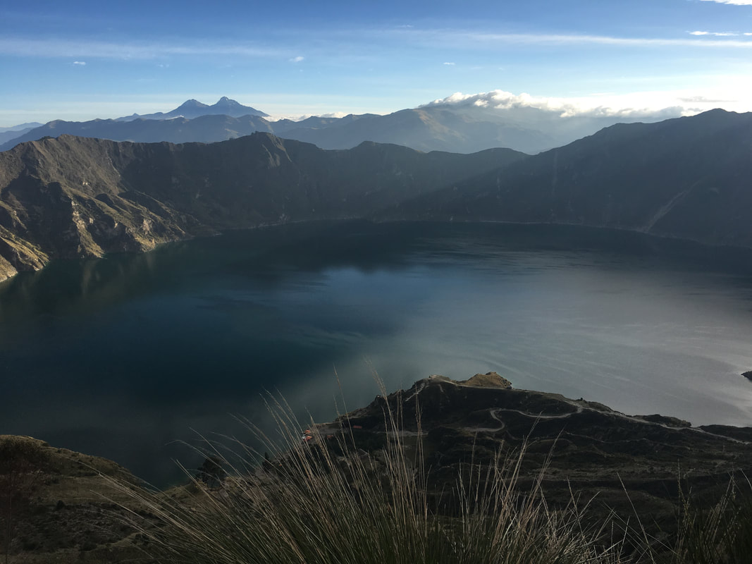
On the overlook to see Quilatoa! |

Our new friend, Gringo |
The hosienda where we ate lunch |

Getting my yoga on at Cotopaxi |
